...A SEVERE THUNDERSTORM WARNING REMAINS IN EFFECT UNTIL 1015 PM CDT
FOR IBERIA...SOUTHEASTERN LAFAYETTE...NORTHWESTERN ST. MARY AND ST.
MARTIN PARISHES...
At 959 PM CDT, a severe thunderstorm was located near Lake Fausse
Pointe, or 11 miles southeast of Catahoula, moving east at 65 mph.
THIS IS A DESTRUCTIVE STORM FOR LOREAVILLE, LAKE FAUSSE POINTE AND
UPPER SAINT MARTIN PARISH.
HAZARD...80 mph wind gusts and nickel size hail.
SOURCE...Radar indicated.
IMPACT...Flying debris will be dangerous to those caught without
shelter. Mobile homes will be heavily damaged. Expect
considerable damage to roofs, windows, and vehicles.
Extensive tree damage and power outages are likely.
Locations impacted include...
New Iberia, Catahoula, Breaux Bridge, Franklin, St. Martinville,
Jeanerette, Avery Island, Belle River, Broussard, Baldwin,
Loreauville, Cade, Butte La Rose, Lydia, Acadiana Regional Airport,
Sorrel, Coteau, Lake Fausse Pointe, Charenton, and Pierre Part.
PRECAUTIONARY/PREPAREDNESS ACTIONS...
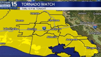
A Tornado Watch remains in effect until midnight CDT for south
central and southwestern Louisiana.
For your protection move to an interior room on the lowest floor of a
building.
Torrential rainfall is occurring with this storm, and may lead to
flash flooding. Do not drive your vehicle through flooded roadways.
&&
TORNADO...POSSIBLE;
THUNDERSTORM DAMAGE THREAT...DESTRUCTIVE;
HAIL THREAT...RADAR INDICATED;
MAX HAIL SIZE...0.88 IN;
WIND THREAT...RADAR INDICATED;
MAX WIND GUST...80 MPH
The National Weather Service in Lake Charles has issued a

* Severe Thunderstorm Warning for...
Iberia Parish in south central Louisiana...
Southeastern Lafayette Parish in south central Louisiana...
St. Mary Parish in south central Louisiana...
St. Martin Parish in south central Louisiana...

* Until 1115 PM CDT.

* At 1012 PM CDT, a severe thunderstorm was located 8 miles west of
Pierre Part, or 10 miles northwest of Belle River, moving east at
70 mph.

HAZARD...70 mph wind gusts and penny size hail.

SOURCE...Radar indicated.

IMPACT...Expect considerable tree damage. Damage is likely to
mobile homes, roofs, and outbuildings.

* Locations impacted include...
New Iberia, Morgan City, Catahoula, Breaux Bridge, Franklin, St.
Martinville, Patterson, Jeanerette, Berwick, Burns Point, Belle
River, Bayou Vista, Cypremort Point, Stephensville, Avery Island,
Broussard, Baldwin, Delcambre, Loreauville, and Ellerslie.

PRECAUTIONARY/PREPAREDNESS ACTIONS...

For your protection move to an interior room on the lowest floor of a
building.

Large hail, damaging wind, and continuous cloud to ground lightning
are occurring with this storm. Move indoors immediately. Lightning is
one of nature's leading killers. Remember, if you can hear thunder,
you are close enough to be struck by lightning.

Torrential rainfall is occurring with this storm, and may lead to
flash flooding. Do not drive your vehicle through flooded roadways.

A Tornado Watch remains in effect until midnight CDT for south
central and southwestern Louisiana.

&&


THUNDERSTORM DAMAGE THREAT...CONSIDERABLE;
HAIL THREAT...RADAR INDICATED;
MAX HAIL SIZE...0.75 IN;
WIND THREAT...RADAR INDICATED;
MAX WIND GUST...70 MPH
The National Weather Service in Lake Charles has issued a
* Flash Flood Warning for...
Southeastern St. Landry Parish in central Louisiana...
Northwestern Iberia Parish in south central Louisiana...
Lafayette Parish in south central Louisiana...
Northwestern St. Martin Parish in south central Louisiana...
North Central St. Mary Parish in south central Louisiana...
Southeastern Acadia Parish in southwestern Louisiana...
Northeastern Vermilion Parish in southwestern Louisiana...
* Until midnight CDT tonight.
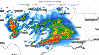
* At 949 PM CDT, Doppler radar indicated thunderstorms producing
heavy rain across the warned area. The expected rainfall rate is 1
to 3 inches in 1 hour. Additional rainfall amounts of 2 to 4
inches are possible in the warned area. Flash flooding is ongoing
or expected to begin shortly.
HAZARD...Flash flooding caused by thunderstorms.
SOURCE...Radar.
IMPACT...Flash flooding of small creeks and streams, urban
areas, highways, streets and underpasses as well as
other poor drainage and low-lying areas.
* Some locations that will experience flash flooding include...
Lafayette, New Iberia, Abbeville, Catahoula, Scott, Breaux Bridge,
Carencro, St. Martinville, Jeanerette, Kaplan, Arnaudville, Avery
Island, Broussard, Youngsville, Erath, Delcambre, Duson,
Henderson, Maurice and Loreauville.
PRECAUTIONARY/PREPAREDNESS ACTIONS...
Turn around, don't drown when encountering flooded roads. Most flood
deaths occur in vehicles.
Be especially cautious at night when it is harder to recognize the
dangers of flooding.
&&
FLASH FLOOD...RADAR INDICATED;
EXPECTED RAINFALL RATE...1-3 INCHES IN 1 HOUR
TORNADO WATCH 249, PREVIOUSLY IN EFFECT UNTIL 10 PM CDT THIS
EVENING, IS NOW IN EFFECT UNTIL MIDNIGHT CDT TONIGHT FOR THE
FOLLOWING AREAS

IN LOUISIANA THIS WATCH INCLUDES 11 PARISHES

IN CENTRAL LOUISIANA

AVOYELLES             EVANGELINE            ST. LANDRY

IN SOUTH CENTRAL LOUISIANA

IBERIA                LAFAYETTE             ST. MARTIN
ST. MARY

IN SOUTHWEST LOUISIANA

ACADIA                CAMERON               JEFFERSON DAVIS
VERMILION

THIS INCLUDES THE CITIES OF ABBEVILLE, BAYOU VISTA, BEAVER,
BERWICK, BRANCH, BREAUX BRIDGE, BUNKIE, BURNS POINT, CADE,
CENTERVILLE, CHURCH POINT, COTTONPORT, CROWLEY, EFFIE, EUNICE,
FORKED ISLAND, FRANKLIN, HACKBERRY, HATHAWAY, INTRACOASTAL CITY,
JENNINGS, JOHNSON BAYOU, KAPLAN, LAFAYETTE, LAKE ARTHUR, LAWTELL,
MAMOU, MANSURA, MARKSVILLE, MEAUX, MORGAN CITY, NEW IBERIA,
OPELOUSAS, PATTERSON, RAYNE, REDDELL, RICHARD, ROANOKE,
SIMMESPORT, ST. LANDRY, ST. MARTINVILLE, STEPHENSVILLE, TOPSY,
VILLE PLATTE, AND WELSH.
...FLOOD WATCH NOW IN EFFECT THROUGH LATE FRIDAY NIGHT...

* WHAT...Flash flooding caused by excessive rainfall continues to be
possible.

* WHERE...Portions of Louisiana, including the following parishes,
Allen, Avoyelles, Beauregard, Evangeline, Lafayette, Northern
Acadia, Northern Calcasieu, Northern Jefferson Davis, Rapides,
Southern Acadia, Southern Calcasieu, Southern Jefferson Davis, St.
Landry, Upper St. Martin, Upper Vermilion and Vernon and southeast
Texas, including the following areas, Hardin, Lower Jefferson,
Northern Jasper, Northern Newton, Northern Orange, Southern
Jasper, Southern Newton, Southern Orange, Tyler and Upper
Jefferson.

* WHEN...Through late Friday night.

* IMPACTS...Excessive runoff may result in flooding of rivers,
creeks, streams, and other low-lying and flood-prone locations.
Creeks and streams may rise out of their banks. Flooding may occur
in poor drainage and urban areas.

* ADDITIONAL DETAILS...
- A storm system will slowly move through the region today and
Friday. Widespread rainfall of 2 to 6 inches is possible with
the potential for 6 to 12 inches locally. Southeast Texas
north of I-10 into south-central Louisiana has the highest
probability of seeing these higher totals. This will fall on
already saturated soils and with ongoing flooding and or
elevated water ways. Rainfall rates with the strongest
showers and storms will be in excess of 2 inches in one hour.
- http://www.weather.gov/safety/flood

PRECAUTIONARY/PREPAREDNESS ACTIONS...

You should monitor later forecasts and be prepared to take action
should Flash Flood Warnings be issued.

&&